The cold today will "ease" a bit Friday and Saturday before another surge of cold air arrives to close out 2017 and start 2018. In fact, the first week or so of 2018 is looking downright cold!
Thursday, December 28, 2017

Tuesday, December 12, 2017
Graupel Formation
We're all familiar with rain, snow, sleet, and freezing rain around here. However, there is another form of wintry precipitation we rarely talk about and had today: Graupel.
Graupel is formed by a collection of super-cooled raindrops freezing around a snowflake. It is softer than sleet and hail and more opaque (white) than sleet. It's also very soft, which is one way you can tell it's not hail.
They are similar in appearance to Dippin' Dots, if you're familiar with those.
Friday, October 6, 2017
Friday, August 11, 2017
Friday, November 11, 2016
Why did the temperature go UP last night?

Something interesting happened to the temperatures along the
Blue Ridge Mountains this morning. CHO was reporting a temperature of 61 at 3
AM after being at 50 at 9 PM the previous night. The temperature did drop back
in to the mid 50s by 7 AM, but that’s not anywhere close to the mid to upper
30s we were forecasting. I mean, some of us did (as shown below), but a good majority of us were in the 50s, close to 60, at 5 AM. So, what went wrong!?

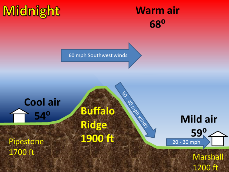
Well, we had a wind from the southwest much of the overnight. This is a traditionally warmer wind for us and is part of the reason we stayed on the warmer side of our forecast. The other part is we had a downslope wind.
Before we talk about a downslope wind, first let’s talk about the geography of Central Virginia. We have the Blue Ridge Mountains in our backyard and are home to the Blue Ridge Parkway, Skyline Drive and Shenandoah National Park. A lesser known mountain chain, though, is the Southwest Mountains, which extends from Nelson County, through eastern Albemarle County and western Orange County. You can drive along this chain on Route 231 (Gordonsville Rd.) from Route 250 to US 33.
Charlottesville is in a unique position being between these
two mountain chains; it’s part of the reason why cold air damming (CAD) is so
tough to scour out (I’ll elaborate on that in a different blog post) and why
temperature forecasts can be blown.
I mentioned the blown temperature forecast from last night (Thursday, November 10th) being due to the downslope winds. So, what are downslope winds? Here ya go:
I mentioned the blown temperature forecast from last night (Thursday, November 10th) being due to the downslope winds. So, what are downslope winds? Here ya go:
Meteorologists break down the atmosphere in to parcels of air. As one of these parcels of air, think of a square box, rise over the
mountains, the pressure above it lessens. According to the ideal gas law
(PV=nRT), that means the temperature (T) must cool when the pressure (P)
decreases thanks to the volume (V), number of moles (n), and universal gas
constant (R) all remaining constant. The inverse is true when a parcel of air
goes down a mountain; the pressure above the parcel becomes greater which means
the temperature must increase. Here’s a rough schematic of what I’m talking
about: http://www.weather.gov/images/fsd/news/ridge2.png

Another thing to consider is the temperature inside that
parcel of air cooling as it goes up the mountains; the temperature gets closer to the dew
point which then produces clouds. However, the temperature warms as it goes
down the mountain (inverse relationship), meaning there is a wider gap between
the temperature and dew point (dew point depression in meteorological terms) as
the air dries out after having a good bit of moisture wrung out of it from the
parcel’s trip up the mountain. The larger the dew point depression is the less
humidity is inside the parcel of air, which means clouds evaporate and the air dries out. Need some
evidence of this? Check out the dew point drop from 9 PM last night through the
morning hours and how it goes back up by 9 AM:

We see this all the time along the Appalachian Mountains. A
strong northwesterly flow across the Great Lakes runs in to the higher peaks of
the mountain chain. As soon as these parcels of air are lifted up along the
mountains, more clouds form; some of these clouds could also produce showers or
snow depending on the temperature. These clouds then evaporate as they go down
the mountain and are the reason why the Appalachian Mountains could be cloudy,
but we are sunny here across Central Virginia.
David Reese
Friday, November 4, 2016
Monday, July 11, 2016
July 11th Evening Forecast Video
A few more clouds roll in from the south in the overnight as a warm front slowly pushes north. This warm front will bring back the humidity, which also ups our rain chances the next couple of days. Temperatures Tuesday morning will be in the mid to upper 60s with afternoon highs in the mid to upper 80s. A few showers are possible in the afternoon, especially along the mountain tops and points just east and west of there.
A few more showers and thunderstorms are expected area wide Wednesday as a piece of energy rolls our way. This piece of energy will also bring more clouds along with it, thus keeping temperatures on the cooler side as we expect highs in the mid to upper 80s once again. High pressure builds in Thursday afternoon, bringing the heat back with it. What do we mean by heat? Well, we’re looking at forecast highs back in the low to mid 90s. There will also be a small chance for rain Thursday afternoon. In other words, this will be very similar to what we experienced most of last week. Friday will be a touch drier as some mid-level dry air arrives from the west. We’ll then bump up rain chances as another disturbance rolls our way this weekend. Yes, the weekend will have better shower and thunderstorm chances. The silver lining, though, is that we’ll see temperatures in the upper 80s to near 90. Which, isn’t all that bad considering where we could be this time of year?
Tonight: Clear to partly cloudy. Lows near 70.
Tuesday: Partly sunny with isolated afternoon showers and storms. Highs in the upper 80s.
Wednesday: A mix of sun and clouds with afternoon showers and storms. Highs in the mid to upper 80s.
Thursday: Hot and humid with isolated afternoon showers and storms. Highs in the low to mid 90s.
Friday: Partly cloudy. Highs near 90.
Saturday: Partly cloudy with afternoon showers and storms. Highs near 90.
Sunday: Partly cloudy with a chance for rain. Highs in the upper 80s.
Monday: Partly cloudy. Highs in the upper 80s.
Tuesday: Partly sunny with isolated afternoon showers and storms. Highs in the upper 80s.
Wednesday: A mix of sun and clouds with afternoon showers and storms. Highs in the mid to upper 80s.
Thursday: Hot and humid with isolated afternoon showers and storms. Highs in the low to mid 90s.
Friday: Partly cloudy. Highs near 90.
Saturday: Partly cloudy with afternoon showers and storms. Highs near 90.
Sunday: Partly cloudy with a chance for rain. Highs in the upper 80s.
Monday: Partly cloudy. Highs in the upper 80s.
Have a great Monday night!
Meteorologist David Reese
Meteorologist David Reese
Subscribe to:
Posts (Atom)