Friday, September 12, 2014

Not feeling like Fall...

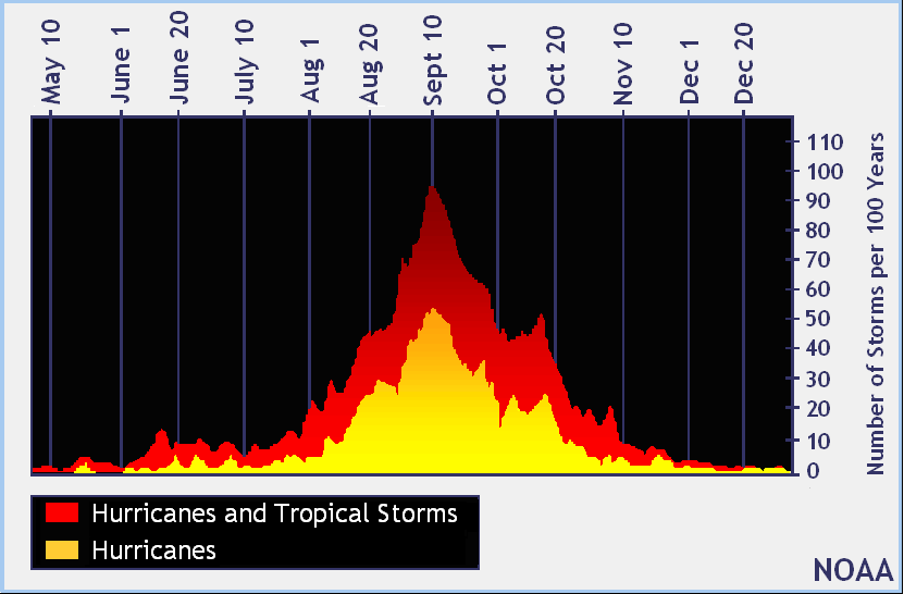
It's the middle of September. The peak of hurricane season just passed. Pumpkin Spiced Lattes are already out at Starbucks, but they were out BEFORE Labor Day. The travesty. (Yes, I've already had a Pumpkin Spice Frappuccino... Couldn't resist!) Pumpkins are already appearing on shelves across the area...

However, don't tell that to our weather! It's been hot, 92° yesterday; humid, dew points have been running in the 70s; and we've been somewhat dry the last few days, which is about to change starting later tonight.

Tonight:
Tonight is the night when a cold front is supposed to get perilously close to us and give us rain. I say perilously because we have High School Football, which is sort of a big deal around here but not as big as baseball, tonight! Those heading out to the games should probably pack the poncho as we look at scattered showers and storms sag south from northern Alabama and Georgia. We aren't looking at any severe weather with these showers and storms, just some rain and a bit of lightning, which can be dangerous out on the field!

The Weekend:
The cold front mentioned above will lose a TON of steam tonight. As a result, the cold front will morph into a stationary front. Sure, it will mosey north and south across Alabama and Georgia over the weekend, but we'll be so close to it that scattered showers and storms remain in the forecast for the duration of the weekend. The showers and storms are most likely after lunchtime and will last into the early evening hours, so Noon~10 PM EDT. Temperatures will climb into the upper 80s to low 90s before the showers and storms fire up.

SEC Football:
The weather could also play an important role during WRBL's SEC Game of the Week as Georgia takes on South Carolina in Columbia. The forecast calls for scattered showers and storms possible throughout the game. Kickoff is 3:30 PM EDT, but it could be the third week in a row we've seen a weather delay due to lightning in the SEC. Florida had their game cancelled against Idaho and Auburn had a lightning delay the first week of the season. Texas A&M also had to deal with a lightning delay of their own last week. We'll see if this game is added to the list...

Just an fyi, Alabama's game against Southern Miss is looking okay with a chance of showers (no thunderstorms) and temperatures in the low 80s.

Early Next Week:
The stationary frontal boundary that plagues us over the weekend will stick around for the first half of the work week. That means more scattered showers and storms in the afternoon with highs in the upper 80s to low 90s.

Tropics Watch:
It's also interesting to note that we will have to keep an eye on the disturbance over Florida. This disturbance is forecast to remain rather weak. It is, however, about to roll into the Gulf of Mexico which has water temperatures well into the 80s. The only thing keeping this disturbance from gaining any strength is an upper low causing some shear. If that fades away (not likely) then we could be looking at a Tropical Depression or Storm in the Gulf. Too early to tell what it wants to do, so stay tuned for that.

Tropical "Swirl" over Florida Friday Afternoon. Moves into Gulf and Could Develop.
Looking Ahead:
Again, this is the place I stick the "voodoo" stuff, or things not likely to happen or that I'm skeptical about in the models. It worked out well last time I posted as the CAD one model was trying to develop early next week isn't likely to happen.

Today's "voodoo" is another cold front late next week the models are advertising. The Euro is dragging a cold front through here Wednesday/Thursday of next week. Meanwhile, the GFS has the cold front getting close, much like this weekend's, before stalling it out very close to us. I have a feeling this cold front will dip a little more south (the trough at 500 mb supports that), but it will still struggle to sweep far enough south of us to tap into fall like weather. Time will tell... Until next time!  Cheers!

Remember to follow the First Alert Weather Team on Facebook, Twitter, and online at wrbl.com/weather

Tuesday, September 9, 2014

Rain Chances Ramp Up Friday

Hello again! It's been a while since I've posted on here as my duties at the station have shifted, but I'm back and hope to do this a little more often than once a year. ;)

Today:
A stationary frontal boundary that's been providing the southeast with a ton of rain has finally sagged south of the News 3 Viewing area which means we'll stay dry for the next couple of days. The front being south of us has also allowed us to see an easterly breeze, developing a stratus deck that is
finally breaking apart around 2 PM this afternoon. There's still another 4 hours of prime heating, though, so we should manage the upper 80s, at least, for highs today.

Next Few Days:
The next couple of days will be highlighted by some rather warm temperatures. Daily highs should easily top the 90° mark Wednesday and Thursday with limited shower and storm coverage to help cool us off. The average high turned the corner yesterday and is finally below 90° with it being 89°. The amazing thing is our average high by September 30th is 82°, so cooler weather is coming!

Overnight lows will remain in the lower 70s. Our average low is 69°, so we're staying above average in both the high and low department.

Friday & The Weekend:
A cold front! Yes, a cold front is scheduled to arrive later this week and into the weekend. The only downside is it will slam on the brakes once it reaches northern Alabama, which means we're likely to stay on the warmer and slightly wetter side of things through at least Saturday evening. The cold front will then trudge south of us later Saturday, but it won't bring a ton of cooler weather with it. If anything, the front will allow us to see lower humidity and lower rain chances to end the weekend and kick off next week. Highs are expected to cool into the mid to upper 80s, which is better than the lower 90s we'll experience leading up to it. Remember to always check out the latest 7-Day forecast at wrbl.com.

Looking Ahead:
Here's where I dive into "Voodoo" land (beyond 7 days) and inform you of what the models are showing. Sometimes, the models are quite entertaining. Other times, they are quite tame. Today's 12Z model runs though were on the more entertaining side of things.

Mid to late next week, the last week of summer by the way, is looking a little cool across the East Coast. Why? Because of an area of high pressure settling over northern Pennsylvania and New York. This high pressure is in prime position to give us a cold air damming (CAD) event next Wednesday through Friday. Couple the location of the high pressure and the stalled frontal boundary/developing low to the south and east of us and you get some ridiculously cool temperatures from the models. Again, this is all for entertainment's sake, but it's still fun to look at nonetheless. 

Below is an image from the 12Z GFS showing temperature (filled & numbered) and pressure (black lines). Anytime you see the black lines "kink" into the southeast from the northeast (like the line going through Atlanta) is a CAD setup.


Sure, these are temperatures for 8 PM next Wednesday, the 17th of September, but take tomorrow night's 8 PM forecast temperatures for a point of reference:

And you see why this is a big deal. That's a 13° temperature drop from one week to the next at the same time! If we were to extrapolate this out then we'd expect the temperatures next Wednesday through Friday to struggle to get out of the 70s for daytime highs. How's that sound for a taste of fall!?

Again, this is out in "voodoo" land in computer models, but it's fun to look at and is always a great way to teach you something in the world of meteorology!


Friday, August 16, 2013

Another Cool Afternoon

Good morning! Another cool afternoon is on tap as highs top out in the mid 70s. The RPM, right, isn't getting a few of us out of the 60s. That's all due to a stiff northeasterly breeze drawing in some cooler air from the Mid-Atlantic, aka CAD or a wedge. We'll be this cool until our winds switch out of the southeast, which should occur later tonight as a frontal boundary inches north. The official forecast calls for highs to top out near 76°, which would make it the second day in a row we've seen record cool highs, with isolated areas of drizzle and a mostly cloudy sky.

That frontal boundary will spark off more showers and storms south and east of Columbus today. Tomorrow, a slug of tropical moisture will throw itself at the front and create even more showers and storms Saturday and Sunday. As a result, all of our Georgia Counties are under a Flash Flood WATCH until tomorrow (wouldn't surprise me to see it extended through the weekend).

Warmer, more average, temperatures look to return next week. The rain chances stay in the forecast as tropical moisture is left behind in the wake of this weekend's rains. Check out the 7-day forecast.

Monday, July 29, 2013

Drier end to July

Good morning! A quick check of the National temperatures shows quite the "fall" like start for parts of the Great Lakes & Ohio River Valley. The cooler air ran in to a road block as it entered the Deep South, allowing us to stay near average.

Our weather will feature a mix of sun and clouds with highs climbing close to average, 92. Our forecast temperature map shows a good chunk of us in the upper 80s, with a few spots, like Columbus & Montgomery, in the low 90s. 
 
Another mostly dry day is expected, hence why we get so warm, as highs, officially, climb to near 90 in Auburn and 92 in Columbus. A stray shower is possible for areas near Eufaula and Albany and south of there, or closer to the stalled frontal boundary.


Shower chances will be limited tomorrow as we stay just north of the stalled frontal boundary. Rain chances slowly increase Wednesday as a disturbance rides along the boundary. The last half of the week will see slightly better shower and storm chances as that disturbance sits over us. A trough will set up shop over the eastern half of the country, with us at the bottom of it. The bottom of the trough is where fronts like to stall out, hence our increased rain chances.

Tropics Update:
Tropical Storm Dorian fizzled over the weekend. It's now an open wave north of Puerto Rico and continues to head WNW at 15-20 mph. Some models attempt to spin up Dorian again, but it's not looking all that likely as it heads for the Bahamas Wednesday. From there, the remnants of Dorian will sweep over Florida and provide better shower/storm coverage for parts of the Deep South, including us, this weekend.

Friday, July 26, 2013

Looking ahead to the weekend


Our Weather:
Drier conditions settled over the area yesterday, only allowing one or two showers to dot the sky. Similar conditions are anticipated today with the greatest chance of a stray shower on the Georgia side of the Chattahoochee River. Highs will top out in the low 90s, or very close to average this time of year.

A storm system in the middle of the country will roll through the southeast tomorrow, bringing the chance for scattered showers and storms at any time. More scattered showers and storms are possible Sunday, but the greatest concentration will be south and east of Columbus. Once this storm system exits the Deep South, drier air will filter in to the region.

Tropics:
Tropical Storm Dorian is holding tough this morning. As of 5 AM EDT, it had winds of 50 mph with a forward speed of 20 mph to the west-northwest. The future track of Dorian puts it north of the Greater Antilles early next week. There are two model camps this morning. The GFS now has Dorian barreling in to Hispaniola, basically killing the storm. The EURO, however, does weaken it quite a bit, but sends the remnants of Dorian through the Bahamas and in to South Florida late next week. The good news, as of now, is that Dorian looks to weaken over the coming days. However, we can't let our guard down because Mother Nature might throw us a curve ball or two over the weekend. We'll have a more concrete idea of what Dorian is going to do early next week, if it even survives that long.

Thursday, July 25, 2013

Tropical Storm Dorian and Cold Front

TROPICS:
Tropical Storm Dorian continues to churn in the far Atlantic. It's looking pretty healthy this morning with clouds tops colder than -70C, illustrating strong storms near the center. It's got a nice, tight circulation and is fighting off cooler water temperatures, 25-26C, as it continues to intensify.
Early satellite view of Dorian 7-25-13
The overall track of Dorian has it going around the strong Bermuda Ridge. It won't get close to the Lesser Antilles until this weekend. From there, it could go one of two directions. Below is the 6Z GFS:
7-25-13 6Z GFS showing Dorian in the Bahamas
This shows a weaker solution, and very close to what the 0Z Euro showed last night, allowing it to be steered more by the low level winds than upper level winds. The other possible track is it curving up the Southeast coast, shown below from the 0Z GFS. This track would occur if Dorian is a bit stronger.
7-25-13 0Z GFS showing a stronger Dorian
Keep in mind... This is still over 3000 miles from the News 3 viewing area and will take a good 8-10 days for it to get anywhere close to the US. It's too early to pinpoint what Dorian's going to bring us, if anything. The best thing to do is stay up to date with the latest track and check in early next week when we have a better handle on Dorian's evolution and future track.

Our Weather:
Cold front over us with rain in OK & TX
A cold front is sliding through the region as we speak. This front is bringing fall-like temperatures to parts of the Ohio River Valley and Northeast. Some locations in the Great Lakes woke up to the upper 30s and a few spots flirted with record lows.

 
Drier, cooler air trying to make it south

Now, that won't be an issue here, but we could see some spots get down into the upper 60s. Our record low, in case you're wondering, is, officially, 66 set back in 1948. I think the official reporting station stays above that, but others near LaGrange and surrounding areas could flirt with temperatures that cool.

The other good thing about this front is it dries us out! Rain chances are virtually zero to close out the week. Don't get used to it, though. Wetter weather makes another appearance this weekend as the mess of rain in the Plains moseys its way over.

Thursday, May 23, 2013

Cold front moving through

A few scattered showers danced around the area late yesterday afternoon and evening. Unfortunately, my house, and many others, stayed dry and will be dry for the foreseeable future.

TODAY:
A cold front is forecast to move through the region later this afternoon, bringing much drier (read lower humidity) and cooler than average temperatures for the weekend. The front will bring a few clouds but not much rain, maybe a rogue shower or two. Highs will once again climb well into the 80s and a few spots may see the 90° mark for a third straight day.

MEMORIAL DAY WEEKEND:
The graphic to the right sums it up. We'll all experience refreshingly cool mornings, low to mid 50s; lower humidity as dew points dip into the low to mid 40s; and highs in the low 80s Friday & Saturday. We'll warm up a bit Sunday & Monday with most escaping the 90° mark until the middle of next week.

We're not the only ones expecting cooler temperatures this weekend. Check out the 2m temperature anomaly map to the left. The blue represents cooler than average temperatures. Not a bad way to kick off the unofficial start to summer!

END OF MAY/BEGINNING OF JUNE:
Computer models still hint at a big ole ridge building over the top of the southeast come the end of next week. If these solutions come to fruition then some could be pushing the mid to upper 90s by the first week of June. This is still a long ways away, but with maps like the one attached below, it'd be difficult for us to escape a few low to mid 90° days.
This ridge will also keep us rather dry to end May and begin June. It's a good thing we picked up all that rain in February as we're still running a rain surplus for the year.


TROPICS:
I mentioned in a blog post over a week and a half ago that something could be brewing in the tropics. The GFS was hinting at a system developing in the western Caribbean, but I mentioned the possibility of it developing in the eastern Pacific instead. Well... If the 00Z GFS is to be believed, we could be talking about a tropical cyclone off the coast of Mexico by Tuesday/Wednesday of next week. This makes sense as the upward pulse of the MJO is forecast to move over the region, enhancing the chances of a TC to form.

I'll then post this image to see how accurate the two week forecast of the GFS is when it comes to the tropics (HA!).