Woke up to lows this morning in the upper 40's around the area. Temperatures could have plunged further, but the winds at about 10mph kept that from happening. The forecast for today is in the upper 60's to near 70 degrees across much of the Chattahoochee River Valley. The weekend looks ideal for all of the ghosts and goblins out there. Highs over the weekend will be in the low to mid 70's and overnight temperatures will dip down in the low to mid 40's. If you're trick-or-treating on Saturday, you may need a jacket as temperatures around 6pm will be in the mid 60's and on Sunday they will be in the upper 60's around 6pm. Our next chance of rain will be into the middle part of next week.
Voters may have to dodge a rain shower or two if you're heading to the polls later on in the day. The best chance of rain will be on Wednesday as our next frontal system moves through and drops our temps into the mid to upper 60's at the end of next week.
Friday, October 29, 2010
Tuesday, September 14, 2010
Tropical Storm Karl
Tropical Storm Karl formed in the Caribbean Sea this evening. Its winds are 45 mph and is moving to the WNW at 15 mph. This movement means the system will be effecting the border of Belize and Mexico tomorrow morning. After moving over land, which will weaken the system to a tropical depression for a time, it will emerge into the Bay of Campeche. Once it does so, Karl will restrengthen into a Tropical Storm once again before heading to the Mexican coastline. Fortunately, for the United States, this system will not be affecting Texas; which is welcome news because they just experienced Hermine's wrath just a little over a week ago.
The reason this system is heading towards Mexico is due to high pressure entrenched over the Southeast. This is allowing all of the tropical systems in this region, so far, to head toward the Mexico-Texas border. Karl will not experience much sheer, and if it holds together over the Yucutan Peninsula, then I would not be surprised to see Karl become a hurricane just before its second landfall. This will not intensify into a powerful storm, just a minimal hurricane. Right now, the forecast track has Karl making landfall Wednesday morning on the Yucutan, and making its second landfall by Friday night.
Again this system is not forecast to hit the United States, but should still be monitored by those living in South Texas.
Here is the forecast track by the NHC:
Wednesday, September 1, 2010
Three Tropical Systems out there!
As of 5pm, we have 3 tropical systems to keep our eye on. First, I'll cover the most important storm, Hurricane Earl.
Earl regained its category 4 strength this afternoon after weakening for a time this morning. Winds are 135 mph, and forward movement is to the NNW at 17 mph. Earl made the turn more to the north late last night, and most computer models have it a little farther to the east than previous runs. However, the Outer Banks still have to watch this system closely as Hurricane Warnings are out for the area. Tonight will see a fairly pleasant night as there is quite a bit of dry air ahead of this system. Tomorrow is a different story. Conditions will deteriorate throughout the day as the storm barrels its way towards the coast. Again, it is forecast to stay offshore, but hurricane force winds (75 mph or greater) are expected.
Tropical Storm warnings extend all the way up the Jersey shore to Newark, meaning tropical storm force winds are anticipated in the next 36 hours. After the brush with the Outer Banks, this system will essentially be a Nor'easter on steroids. Winds will be blowing at least 50 mph along the immediate shore line of the entire east coast north of Cape Hatteras. These winds will also be onshore, meaning coastal flooding and some storm surge is going to be a problem for those of you who live along the immediate coastline.
Hurricane watches are now posted for the extreme eastern portions of Massachusetts, including Nantucket and Cape Cod. With tropical storm watches for the surrounding area. Here you can expect low grade hurricane force winds, and coastal flooding as well. Swells out in the ocean can exceed 10 feet, so don't be out in the water.
Now, for Tropical Storm Fiona. It's winds are currently at 60 mph, and it is forecast to turn more to the north as the same trough that is picking Earl up is also going to pick Fiona up and drag it away from land. That's the good news. The bad news is this storm could stall out over the open waters of the Atlantic. This will cause wave action to continue to be extreme up and down the East coast for the Labor Day weekend!
I cannot stress enough, Stay Safe during this time period. The swells are going to be large and rip currents are a real concern, even after the storm passes. If you get caught in a rip current, let it take you out and when you feel it stop pulling you away from shore, then swim parallel to the coastline until you don't feel it pulling on you, and swim safely back to shore.
Last, but certainly not least, is Tropical Storm Gaston. Its track is moving to the WNW at 15 mph with winds sustained at 40 mph. It is supposed to continue on this track to the WNW for the next 4 to 5 days. Long range, though, could see this system over the Leeward Islands(about in the same tracks as Earl and Fiona are tracking). The difference for Gaston though is that a trough is not anticipated to be digging south. That means this system will continue on it's WNW track for an extended period of time. The longer it does this, the more in danger the East coast of the United States faces.
Meteorologist David Reese
Monday, August 30, 2010
Hurricane Earl
Radar Image of Hurricane Earl from San Juan, Puerto Rico at 5pm EDT (image courtesy of Wunderground.com) Notice the well developed Eye on Radar. The storm is breezing to the north of San Juan and the rest of Puerto Rico this evening, meaning Puerto Rico will not take a direct hit from this system.

Satellite imagery of Earl: Notice the well developed eye!
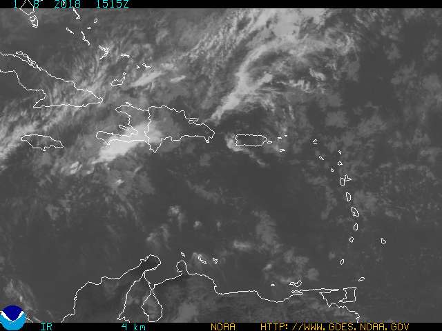
As of 5pm, Hurricane Earl is located just to the northeast of Puerto Rico with sustained winds at 135 mph, making it a category 4 storm. The eye is becoming more developed as the day progresses and continued strengthening is not out of the question. The forecast track of this system is for it to make the turn to the north relatively soon. It DOES matter when this storm turns to the north. If Earl continues it's motion to the WNW at 15 mph for longer than the anticipated 24 hours, then we could be talking about a major hurricane hitting the Outer Banks of North Carolina. If it does this then the entire Northeast will be affected by this system with strong winds and storm surge to the north of the system. That again is worst case scenario. For now the general thinking is the trough of low pressure will dig down quickly and drag this system just off the East coast of the United States.
Here is the forecast track by the NHC:
![[Image of 5-day forecast and coastal areas under a warning or a watch]](http://www.nhc.noaa.gov/storm_graphics/AT07/refresh/AL0710W5_NL+gif/204613W5_NL_sm.gif)
Notice the cone of uncertainty still includes portions of the Outer Banks and the entire Northeast. Interests along these areas should be keeping a watchful eye on this system and make sure you have everything in your emergency kit prepared.
I think this system will just brush up against the Outer Banks and continue up the East coast providing tropical rain and strong winds for much of the Northeast.
Meteorologist David Reese
Satellite imagery of Earl: Notice the well developed eye!
As of 5pm, Hurricane Earl is located just to the northeast of Puerto Rico with sustained winds at 135 mph, making it a category 4 storm. The eye is becoming more developed as the day progresses and continued strengthening is not out of the question. The forecast track of this system is for it to make the turn to the north relatively soon. It DOES matter when this storm turns to the north. If Earl continues it's motion to the WNW at 15 mph for longer than the anticipated 24 hours, then we could be talking about a major hurricane hitting the Outer Banks of North Carolina. If it does this then the entire Northeast will be affected by this system with strong winds and storm surge to the north of the system. That again is worst case scenario. For now the general thinking is the trough of low pressure will dig down quickly and drag this system just off the East coast of the United States.
Here is the forecast track by the NHC:
Notice the cone of uncertainty still includes portions of the Outer Banks and the entire Northeast. Interests along these areas should be keeping a watchful eye on this system and make sure you have everything in your emergency kit prepared.
I think this system will just brush up against the Outer Banks and continue up the East coast providing tropical rain and strong winds for much of the Northeast.
Meteorologist David Reese
Subscribe to:
Posts (Atom)