Friday, December 30, 2011

Fog early then warmth

Good Friday morning!

A few more warm days are in store before the first chill of Winter moves in next week. 

Friday:
It's the last Friday of the year and it's going to be a warm one, relatively speaking. Enough moisture is being pulled up from the Gulf Coast to allow fog to develop this morning. The fog will dissipate and make way for a mix of sun and clouds this afternoon. Highs top out near 66.

Weekend:
A southwesterly flow the next few days will keep us almost 10 degrees above average to end 2011 and start 2012. Another weak front will attempt to move in tomorrow but won't have enough energy to produce any showers. On the other hand, Sunday's front will have enough moisture to pop a few light showers. Even with a mostly cloudy sky, I'm forecasting highs in the mid 60s. Back behind that front will be the coldest air of the season so far.

First week of 2012: 
We're still forecasting a trough to pull down the coldest air of the season. Models are finally coming into agreement about the extent of the cold. GFS MOS has us in the mid 40s, finally, while the raw data still has us in the upper 30s for Tuesday, our coldest day next week. We'll then moderate some into the upper 40s to near 50 for Wednesday. Another thing to watch out for next week will be the windy conditions as the cold air spills south. Winds are forecast to be anywhere from 15 to 25 mph with higher gusts.

The cold air and winds will ease up by the latter half of next week but just how much we'll moderate is yet to be determined. Here's why:

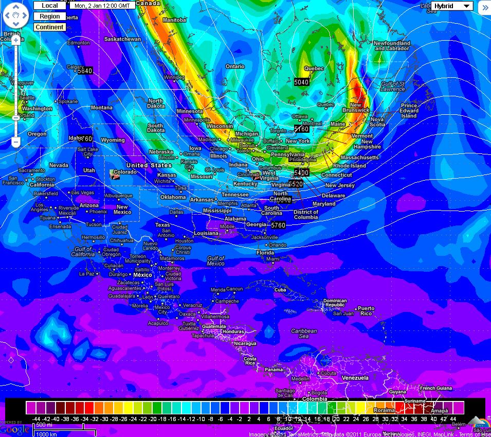
00Z GFS for Thursday night:

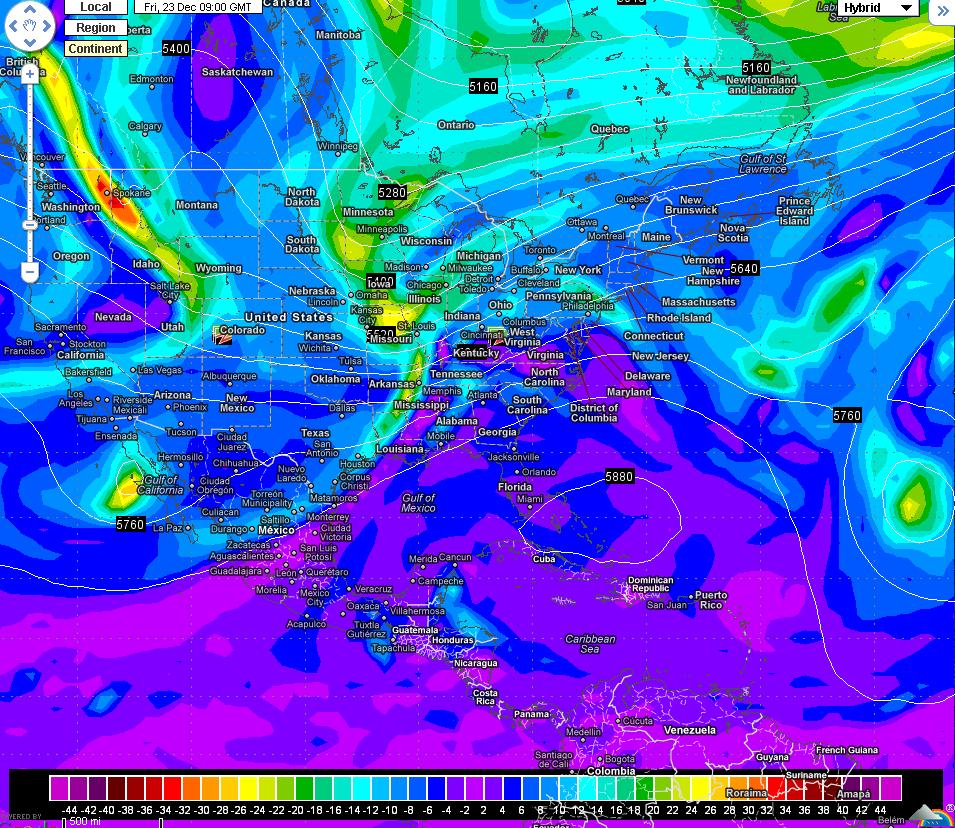
00Z Euro for Thursday night:

The models are night and day in regards to the second piece of energy, mentioned in yesterday's blog, on the back side of the trough. The GFS cuts off a low over Texas and leaves it there for a day or two before ejecting it northeast through the Tennessee River Valley. If this were to occur, we'd be a southwesterly flow aloft and we'll be near 60 or above by next weekend. Compare that to the Euro which has the energy skirting our area. This keeps us cool with highs in the upper 40s. Either way, the cold won't be sustained.

It'll be interesting to see what the models do over the next few days with this second piece of energy. They could forecast something in the middle, likely, something like the GFS, not as likely, or something like the Euro, not as likely as the middle of the road solution but more likely than the GFS. It's basically a wait and see forecast until we see how strong the initial trough is and where the energy comes ashore in the west coast.

Indices:
I'll leave you with this nugget of information : The PNA is going to go negative again, NAO is still positive, AO is still positive. Those indices provide more proof that this won't be a sustained cold shot. HOWEVER, at the end of the two week forecast period, the PNA is looking to go positive and both the AO and NAO are forecast to go negative by the middle of the month. That's pretty significant because if those verify, we will be talking about a cold end to January. It's not set in stone by any means, just something I'll keep an eye on over the coming week.

Thursday, December 29, 2011

Cold start to 2012

Good Thursday morning!

After an average day yesterday, we'll begin a warming trend to end 2011. A few weak disturbances will ride along the jetstream; allowing me to forecast a few high clouds the next couple of days.

Today:
Morning lows are dipping into the low 30s on the heels of a relatively clear sky, a few high clouds for our southern viewers, and calm winds. As with yesterday, we'll see a mostly sunny sky that will warm us up near 60.

Tomorrow and Saturday: 
As mentioned at the beginning of the post, 2011 will end with a warming trend. Highs increase a few degrees each day with low to mid 60s tomorrow and mid to upper 60s Saturday. At least you don't have to worry about the weather if you're making New Year's Eve plans outside as it will be dry and mild. Both afternoons will see clouds stream through as a series of weak disturbances ride along the jetstream.

First week of 2012: 
Monday - Wednesday: 
If you've followed this blog the past few days, then you know about the big chill that's about to invade the eastern half of the country next week. The models are coming into better agreement with the location of the initial trough. The GFS has come in a tad stronger but the overall location is still for the northeast. The Euro is not as strong and is locating farther to the northeast. This is the trend I mentioned a few posts ago. The Euro looked a little too extreme earlier this week while the GFS didn't look strong enough. This solution looks more plausible, at least to me, and will likely be what happens next Monday. Here are the images:

00Z GFS:

00Z Euro:

Either way, that's a mighty cold look for us in the southeast. I'm forecasting highs in the mid 40s for Tuesday and Wednesday, with the chilly weather continuing into the end of the week. As of now, the raw model data has us in the upper 30s next Tuesday and low to mid 40s next Wednesday:
The MOS numbers, taking the raw numbers and combining them with climatology and other factors, are a great deal warmer. The GFS has MOS numbers in the low 50s next Tuesday and Wednesday. That is WAY too warm! The image above is more likely to happen than that. I'm going colder than the MOS numbers but not quite as cold as the raw numbers, as illustrated in the First Alert 7-Day Planner. Needless to say, this is the first real cold snap since the beginning of February.

Thursday - Saturday: 
The models are amazingly similar with the second piece of energy, mentioned at the end of yesterday's post, forecast to ride down the back of the trough mentioned above.

00Z GFS for next Thursday morning:

00Z Euro for next Thursday morning:
The models show the second piece of energy around the Louisiana/Arkansas border. This will continue to round the base of the trough and eventually go negative tilt. The timing of it going negative tilt will have big ramifications on the forecast for the East Coast next week. It's waaayyy too early to be specific but right now I'm not expecting much from this piece of energy. If anything, it will help reinforce the cold air and keep us cold through Saturday. That's not to say something won't change, because it will, but it's something I'll keep an eye on over the next week.

Wednesday, December 28, 2011

Average day with BIG Changes next week

Good Wednesday morning!

What a difference 24 hours makes! All the rain from yesterday morning is now well off the coast and cooler air is firmly in place. This cool spell won't last long as we begin a warming trend tomorrow that extends into the New Year. We're watching the first part of next week closely as I'll detail later in the post.

Today:
Morning lows will fall into the upper 30s, meaning we won't get near the freezing mark. That's pretty significant considering we haven't seen temperatures at or below freezing since December 1st. Just a random statistic for ya this morning. A clear sky will allow abundant sunshine to reach the ground. This warms us into the mid 50s, which is average for the end of December. This will be the last average day, high temperature-wise, for the year as we begin a warm up tomorrow.

Sun in the forecast for the rest of 2011:
High pressure will settle in from the Ozarks later this evening. With calm winds and a clear sky, we will be in the mid 30s, with a few low 30s sprinkled in, tomorrow morning. The high then moves to our southeast which gives us a southerly wind flow; warming us a few degrees each day through New Year's Eve. A few high clouds are possible Thursday and Friday in response to a few weak disturbances riding through, but they won't contain any rain.

Cold start to 2012:
I've been talking about the first few days of the New Year being on the chilly side. The Euro has been consistent in bringing a deep trough into the eastern half of the country. The GFS continues to bring the trough through the northeast and isn't nearly as deep as the Euro. Which model will win out? It's tough to say at this time but there's a growing consensus that it will be closer to the Euro's solution. Here's a look at what the models are depicting for Monday morning, the time frame I've been using the past few days:

00Z GFS:

00Z Euro:
Comparing the GFS to its previous 00Z run shows it's a bit deeper and farther west. The ridge over the Rockies is a good deal sharper this run which sets the stage for a deeper trough to develop than is shown currently. It also shows a dry frontal passage late Sunday/early Monday. After the front passes we'll cool off a good deal to the low 50s. That's the GFS. The Euro is much stronger with the trough although it is slightly weaker this run. The main culprit is the slightly weaker ridge out west. This rounds the trough more for the east coast. It's also a bit more east this run compared to yesterday's which decreases the amount of rain its giving us in the same time frame as the GFS. The Euro then has the trough digging in right over the top of us which would give us a cold Tuesday and Wednesday. When I say cold, I mean cold! The model is painting highs in the low to mid 30s with overnight lows in the teens. The GFS is showing the trough getting deep in the western Atlantic, which puts us in a northwest flow aloft. That will draw down some cool air but not as cold as the Euro.

Alright, now that the comparison of the models is done let's get to what I think will happen next week. First of all, the models are picking up on a pattern change. This usually causes chaos in the models and is more than likely the reason why we are seeing such a discrepancy between the GFS and Euro. The PNA, described in previous posts, goes positive for a brief period of time. The AO, Arctic Oscillation, goes less positive which means a cooler east coast generally. The NAO, North Atlantic Oscillation, doesn't go negative, which also gives us cold air in the east coast, but goes close to neutral. All of those combined leads to a greater confidence in the cold snap depicted by the Euro and CMC, another reliable model. In the end, I'm siding more with the Euro this morning as it's not as extreme as yesterday. I'm not expecting highs in the 30s, yet, but mid 40s are likely next Tuesday and Wednesday.

For my friends in North Carolina, your snow that the Euro gave you yesterday was taken away today. That's because the Euro is a bit more east with the trough and shoves the surface low out into the Atlantic. This is the likely scenario as the UKMet and CMC agree with the Euro. The only hope for snow will be in the mountains.

Disclaimer: This is way into the model runs and should be taken with a grain of salt.
Now that I have the next 7 days out of the way, I'll talk about what the models are showing for late next week. All models are in fair agreement with a secondary piece of energy riding down the back side of the trough. The EURO and GFS both show it. In fact, this secondary piece of energy is the reason why the GFS gets us cold late next week with the northwesterly flow aloft. The Euro has the second piece of energy diving WAY south into Alabama which would give hope for those in the southeast for some wintry precipitation. It's NOT a given, just giving you an analysis of the models this morning! If, and that's a big IF, we can keep the positive PNA with some high latitude blocking then we can start talking about winter mischief. Until then, enjoy, or prepare, for the cold snap in store next week.

Tuesday, December 27, 2011

Rain moving out

Good Tuesday morning!

Pitter-patter, pitter-patter, pitter-patter. That was the sound of rain many of us fell asleep to last night. It's also what some us are waking up to this morning. It won't last much longer as the back-end of the rain shield is passing through as I type. Cooler air will take the rain's place this afternoon. Don't expect temperatures to rise much throughout the day as clouds hang tough, although a few rays of sun are possible late this afternoon.

Today: 
As illustrated on our Interactive Radar, the rain is coming to an end and should be out of the area by 8 AM ET. The cold front will then pass through cooling us off this afternoon. I'm forecasting temperatures to hold steady throughout the day. A few peeks of sun could ruin that forecast but it's enough of a concern for me to mention it here. A clearing sky will be the story this evening as we cool off big time. Lows are forecast to bottom out near 36 with the cooler spots dipping into the low 30s.

Rest of the Year:
We'll call for a good deal of sunshine to finish 2011. Highs will steadily rise from 54 degrees tomorrow to the mid 60s by Saturday. A few high clouds are possible Thursday morning as a weak disturbance rides on by. Clouds will increase Saturday afternoon as we get back into a southwesterly flow. Other than that, enjoy the rest of 2011!

2012:
No, I'm not talking about the movie but possible cold front for January 2nd. This front will be tricky to forecast as the models start to diverge in their solutions BIG time. The GFS is sticking to its guns with a trough in the northeast. On the other side of the coin, the Euro has a deep trough in the eastern half of the country next Monday. Here's what I mean:

00Z GFS for Monday morning:

00Z Euro for Monday morning:

The GFS is slightly weaker in its solution with the trough not as strong. This looks to bring a quick shot of cold and snow for the Northeast before moving out again. With the weaker solution comes a lesser chance for rain next Sunday/Monday. The Euro, however, still shows a strong, though more positively tilted, trough over the Ohio River Valley. This would send down the coldest air of the season for much of the country. It also drags a cold front through the Deep South Monday afternoon and cools us off big time. In fact, 2m temperature forecasts from the Euro has us getting into the teens Tuesday morning! That's NOT likely to happen! Yes, it will be cooler for the first week of 2012 but it won't be super cold like last year. Right now I'm going with a blend of the Euro and GFS with a chance for rain Monday, which the Euro is showing, with seasonable temperatures, which the GFS has. The teleconnections, detailed some in yesterday's blog, continue to indicate a cool down for the eastern half of the country. How strong the indices get remains to be seen but the overall trend is for a cooler, more seasonable start to the New Year.

Remember to check out the 7-Day Planner to plan for New Year's Eve!

Monday, December 26, 2011

Another round of rain!

Good Monday morning!

We saw a great deal of rain yesterday. Officially, we picked up just over half an inch while some of our weather watchers picked up closer to an inch. If you didn't pick up enough rain yesterday, there's another chance this evening as a cold front sweeps through the Deep South.

Today/Tonight: 
The cut-off low that brought a White Christmas to West Texas will finally eject eastward. A surface low develops underneath the cut-off low and forms a cold front. The rain shield won't arrive until this evening with the heaviest rain expected tomorrow morning. Models are giving us another half inch to inch of rain, which lines up well with the Hydrometeorolical Prediction Center's (HPC) forecast. There will be enough instability to call for a few thunderstorms in the overnight hours. They will stay below severe criteria though!

Models output:

HPC Forecast for next 2 days:

We'll warm to near 60 this afternoon as a warm front lifts north this afternoon. Tomorrow will be much cooler, even if the actual high won't seem that cool.

Tomorrow:
The heaviest rain will be early in the morning, when many of us are sleeping. Be sure to tune into New 3 This Morning @ 5 AM ET to track the rain with me! It's a tricky high temperature forecast. We're calling for highs to reach 58 degrees, though we will likely reach that in the early morning hours. Temperatures will fall as the front passes through and clouds linger. If you're heading out tomorrow afternoon, we'll call for temperatures in the upper 40s to low 50s.

Rest of the week: 
Cold air advection (CAA) will allow me to forecast highs in the mid 50s Wednesday and upper 50s Thursday despite abundant sunshine. A few high clouds are possible Thursday afternoon as a weak, upper level disturbance passes by. Friday will feature another mostly sunny afternoon with highs in the low 60s. New Year's Eve is looking pleasant and warm with highs in the mid 60s.

2012:
The New Year will start off on the mild side and a front knocking on the door. The Euro and GFS are at odds with next week's forecast, big shocker I know. The GFS is more progressive, fast, and doesn't have as deep of a trough as the Euro, which has the trough much deeper and farther west. I'm siding with the Euro in this case as it has proved to be the more accurate model in the longer range.

00Z GFS for next Monday:

00Z EURO for next Monday:
If the Euro's forecast were to come to fruition, then it will get mighty chilly next Tuesday and Wednesday. Here's a reason why: The Pacific/North American (PNA) index, which is an index that tells whether we have a ridge in the west coast of the US or not, forecast to go positive. That means we'll see a ridge build over the western states which translates to a colder east coast. It all depends how positive the PNA goes as to how strong and sustained the cold snap will be. Like I said earlier in this post, the Euro seems more likely so cold air will greet us the first week of 2012. If we can have the cold air in place and another system develop near the Gulf then we could talk about wintry precipitation for portions of the Southeast. It's WAY too early to speculate on that but it is looking better for cold air to settle in.

Friday, December 16, 2011

Rain goes poof!

Good FRIDAY morning!!! It's been a long work week, but we have finally made it to the weekend!

Another warm day is on tap. A front has stalled in western Alabama and will take its sweet ole time to get here. Once it does, don't expect much rain, if any.

Today:
With the front still to our west, I'll forecast another warm afternoon. Highs will not get near record territory, 82 is the record in case you were wondering, but they'll still reach the low 70s. A few more clouds will stream through but, like yesterday, they'll mainly filter the sunshine more than anything. Later tonight, as the front approaches, the clouds will thicken but won't contain any rain. The strong southeastern ridge will shove much of the moisture north and prevent it from reaching us.

Here's a quick glance at where the front is currently on the surface plots. Notice how West Georgia/East Alabama is seeing SW winds while Mississippi is seeing northerly winds, that's the front.


Weekend:
The front will push through the area tomorrow morning, allowing us to cool off to near seasonal averages, although slightly above. It will be a welcomed reprieve for many who are looking to get in the Christmas spirit. Highs will reach the low 60s, yes I had to bump tomorrow's high down a peg or two, both days with plenty of sunshine. The reason I've had to bump temperatures down is due to the northwesterly flow aloft, 15,000+ feet, that will help draw in the cooler weather from the Great Plains.

Next Week #1: 
I'll be detailing two separate systems next week. The first will impact us late Tuesday night/early Wednesday morning. I've mentioned this system the past few days and there are a few changes to mention. First, the GFS has sped the front up and brings it through Tuesday evening. However, the Euro brings the bulk of the rain through Wednesday morning. I'm using a blend of the models, splitting the difference essentially; with the showers, maybe a thunderstorm or two, moving through after midnight Wednesday. Here's an illustration of what I mean by the difference in timing:
00Z GFS Tuesday afternoon:

00Z Euro Tuesday afternoon:
Both models drag a line of showers through here, but the exact timing will be worked out next week. I put out a preliminary rainfall total for this system and I'm sticking to it for now until I see something to tell me otherwise. I forecasted around 0.25", although if we do see a thunderstorm or two there would be locally heavier amounts. After the front moves through, temperatures will fall back into the low 60s for Thursday.

Next Week #2:
As mentioned at the end of yesterday's blog, there's a storm brewing for the end of next week. An upper level disturbance, or short-wave, will move through Arkansas and create a surface low that will track through northwestern Alabama. We'll be on the wetter side of the low. If you want to see snow, we'll need to get this low to track south of us; which, I hate to be the Grinch, will not happen. If anything, I wouldn't be surprised to see this low move farther northwest, leaving us drier than currently depicted by the models.
00Z GFS next Friday:

00Z Euro next Friday:

You can make out the front in the maps above with the greens and yellows across Mississippi, especially on the GFS. The brighter the colors, the more lift there is in the atmosphere equaling more rain. This translates to the surface in the form of a surface low pressure which is how we typically, not always, get substantial rains. The Euro isn't as gun-ho about the rain next Friday, it still has it but not a deluge like the GFS is currently showing. This low will have some cold air to develop snow on the northern side of it but that's not going to be an issue for us. If recent history has told us anything, this low will develop a bit more to our northwest than currently forecast but not by much. I am forecasting rain next Friday/Saturday with the timing needing to be worked out next week. Regardless, the front should usher in seasonable temperatures for Christmas morning which would be a pleasant gift! I will tease you with this bit of information: The Canadian model, another model I analyze, has us getting quite cold just after Christmas and is something I'll keep an eye on the next few days.

Enjoy your weekend! Here's your First Alert 7-Day Planner!

Thursday, December 15, 2011

Front knocking on our Door

Good morning! Was it warm enough for you yesterday? We made it to 72 degrees, 13 degrees above average.

I've been talking about a cold front bringing us rain the next few days. Well, the cold front is indeed coming but don't expect much rain. Ahead of the cold front will be some abnormally warm temperatures, so stay cool!

Today:
Abundant sunshine, filtered through high clouds at times, will allow us to reach the low to mid 70s. Our record high is 77. We shouldn't get that warm but it will feel more like Spring than Winter (well almost winter). The cold front is located in Arkansas and western Tennessee, but will take a leisurely stroll through the Deep South.

Friday/Saturday:
As mentioned above, we aren't expecting a ton of rain with this cold front. Here's a look at tomorrow's expected rainfall as forecast by the HPC:

The Bufkit profile, showed in yesterday's blog, shows the same story: DRY! The southeast ridge, a mainstay during La Nina winters, is rearing its ugly head. It is much stronger than previously thought, which means most of the moisture will lift north before it gets here.

Next Week:
After a brief respite from the warm weather this weekend, we'll warm right back into the upper 60s by Tuesday. You know what that means; another cold front will attempt to invade the southeast. I've talked about this system the past few days and I still expect it to give us a decent chance for rain. It's way too early to forecast the amount of rain we'll pick up, but if I had to put a number out there, I'd say around 0.25". That's it. The track of the low will take most of the moisture toward north Georgia/Alabama. The models have slowed this system down and it isn't forecast to enter the southeast until Wednesday, so my Thursday call earlier this week might not be too bad. Here are the two models, GFS and EURO, for next Wednesday:
GFS for Wednesday afternoon:
EURO for Wednesday afternoon:
There are some differences between the models, as expected, but we're still looking at a slower system. The moisture associated with the front will pass through Wednesday afternoon. The GFS is back to it's northerly track, near the Great Lakes, while the Euro has a closed-low moving through the Ohio River Valley. This makes the EURO the wetter solution, but I'm not buying it completely. I'll refine this forecast over the next few days and keep you up to date with my latest thoughts.

Christmas Weekend: 
It's that time of year to start thinking about holiday travel. The GFS has a nice little surface low tracking to our northwest Christmas Eve. This solution could provide us with a wet, not white, Christmas but it's too far out to be specific. I do agree with this set-up as we've been tracking a cold front or low every 4-5 days, so the timing makes sense. I'll watch this over the next few days and make a better forecast with this system sometime over the weekend.

Check out your First Alert 7-Day Planner!

Wednesday, December 14, 2011

More sunshine!

Good Wednesday morning! We're halfway through the week and it's only going to get warmer.

Another round of sunshine will greet you this morning before a few high clouds pass through later today. Temperatures will warm into the low 70s, a few spots may even see 74/75. These highs aren't close to the record high, 78, but are well above average for December.

Today:
Wake up temperatures are in the mid 40s for most, with the lone 50 degree reading in Auburn. As you're at work, the sun will do its job and warm us nicely into the low to mid 60s by lunchtime. A few high clouds start entering the picture later today, but they won't stop us from warming into the low 70s.

Friday/Saturday:
The cold front I've been advertising the past few days will get hung up across the Tennessee River Valley tomorrow night. It will take another impulse of energy and a strong northwesterly flow aloft to kick front through our area Saturday morning. Even though the cold front will bring copious amounts of rain to parts of Tennessee and Mississippi, it won't bring a whole lot to our neck of the woods. Here's a look at the Bufkit precipitation chart for the next week:

As mentioned in yesterday's blog, I'm forecasting us to pick up less than a quarter of an inch of rain. There's just not a whole lot of moisture or right dynamics in place to give us a good soaking.

Next Week:
Alright, I've been detailing next week's system for the past few days and there are a few changes to report this morning. The models have COMPLETELY flipped; the GFS now looks like the EURO from yesterday, while the EURO looks like the GFS from yesterday... Oh the joys of forecasting! Today, the GFS has the closed-low in the same position as the EURO yesterday and moves it into the Central Plains States. A secondary piece of energy will rotate around the base of the trough next Wednesday and provide us a chance for rain. Here's what I'm talking about:


The EURO, though, is much like the GFS yesterday. It still has the closed-low in northern Mexico but it ejects the low into the Great Lakes by next week. A cold front associated with the low will sweep through the Deep South here next Wednesday. With this solution, we wouldn't cool off as much as the GFS has us cooling off as we stay in a westerly flow aloft:

A cold front will move through the southeast next Tuesday/Wednesday, a tad earlier than my forecast the previous two days. It remains to be seen whether we see a lot of rain or even much colder weather as we head into Christmas. This system could create a few headaches for those trying to get north for Christmas with great amounts of rain possible for the northeast. I will note that the GFS Ensembles are looking much like the EURO at this time.

As always, check out the First Alert 7-Day Planner to plan for your weekend!

Tuesday, December 13, 2011

Warming Trend Begins!

Good morning!
 
Were you able to stay warm yesterday? Our official high was 50, a good 10 degrees below average. Today will be much different. A good supply of sunshine and southeasterly winds will warm us a few degrees ABOVE average. A southerly wind tomorrow will warm us into the upper 60s with a few locations touching that 70 degree mark. This roller coaster of temperature swings continues.

End of Week:
A cold front is forecast to chug into the Tennessee River Valley before coming to a screeching halt Thursday evening. It will stall out just to our north so the chance for rain will be best for our neighbors to the north Thursday night. An upper level ridge will provide the umph needed to sag the front south of our area Saturday afternoon so Friday looks to be the best day for rain. Here's the rainfall forecast issued by the HPC for Friday thru Saturday:
The heaviest rain will fall closer to where the front stalls; northern Alabama and Georgia. Locally, we're expecting less than a quarter of an inch.

Long Range:
Next week, the week before Christmas, looks interesting. A strong trough, or closed-low depending on what model you investigate as I'll show you in just a minute, is forecast to move into the Desert Southwest. Like many before it, this trough will lift northeast into the Midwest. Now, the tricky part will be determining just how far northeast this trough goes. Here's what I mean:

00Z GFS 500 mb @ hr 150:
00Z GFS 500 mb @ hr 180:
Compared to the EURO at the same hours:
hr 150:
hr 180:
That's quite a difference between the two more reliable models. The GFS has the trough as an open wave moving through northern New Mexico which ejects toward the Great Lakes by Tuesday morning. The Euro has a closed low in northern Mexico and has it taking a path through the Midwest next Tuesday morning. The path all depends on how the southeast ridge is modeled. Models have been overdoing the strength of the southeast ridge, a staple of La Nina winters which we're in a weak Nina now. If the SE ridge is flatter, not as strong, then the Euro solution is more likely. The opposite is true if the ridge is stronger.

Right now, I'll lean more with the Euro as it has a little more support from its Ensembles and the GFS Ensembles. It's something to watch because areas to the northwest of the low will see quite a bit of snow! No, I'm not forecasting that for us, but it's something fun to watch as we inch closer to Christmas. I'm still holding with my forecast from yesterday that the front, associated with the low, will sweep through next Thursday; bringing us our next chance for rain.

Back behind the front will be some colder air. If we can get another disturbance to cause some overrunning precipitation, which appears possible with the Euro, then parts of the Carolinas could see some wintry precipitation. This doesn't look possible for us, just wanted it noted to see how well I forecasted. ;)

Remember to check out the 7-day planner to figure out what the weather will be like this weekend!

Monday, December 12, 2011

Cold Rain!

Good Monday Morning! I hope everyone had a wonderful weekend!

If you haven't been watching, I've been talking about a few sporadic showers with a few more rounds possible this afternoon. All the clouds and rain will keep us quite cool! The sun should return tomorrow afternoon but it will still have to deal with those pesky high clouds. Highs will warm each and every day this workweek as illustrated in the First Alert 7-Day Planner.

Now:
Showers are the name of the game. The heaviest activity rolled through between 4:30 and 7 this morning with the heaviest activity across southeast Georgia, where they desperately needed it. Locally, we've picked up 0.62"! This is beneficial as it will cut into our 8.86" deficit for year. Clouds and rain have kept us all in the low 40s this morning and won't allow us to warm all that much this afternoon. Remember to check out the Interactive Radar before you step out the door this morning to find out if the rain is over your house!

Here's a peek at the radar, showing the heaviest activity through Chambers, Harris and Talbot counties, as of 7:40 AM:


This Week: 
If you remember last week's blog posts you'll remember me talking about a chance for rain later this week. I still have the chance in there for Thursday night and Friday morning, but don't expect a deluge. Here's why:

00Z GFS (YES, I started using the same site, wunderground, to keep things consistent for you):
There's the trough, draped across Kentucky, that was forecast to sweep through the area. In fact, if you remember earlier last week, the GFS showed a cut-off low moving through the Deep South. This is CLEARLY not going to happen and I'm glad I didn't bite on that solution as it didn't have much support from other models (another great example why you can't look at only one model when forecasting).

Here's the 00Z EURO for the same hour (Thursday night):
This shows a weak disturbance, piece of energy or shortwave, moving through northern Alabama creating an area of lift to initiate a few showers late Thursday/early Friday. Both models show a front draped just south of the Ohio River Valley that will be hard pressed to sweep through the Deep South. That's why I'm forecasting a chance for rain Thursday evening. The front will finally push through the area overnight Friday, dropping our temperatures back into the mid 60s this weekend.

Long Range: 
Another thing I enjoy doing in this blog is forecasting the 7 to 10 day range. Here's an image off the GFS for next Sunday night:
There's a trough lifting out of the Four Corners region and looks to be heading for the Great Lakes region. A quick glance at the GFS Ensembles shows this solution might be a bit too progressive, fast, and opens the low too early. I expect the low to lag back across the southwest and spin for a few days, as shown by the EURO:
So what's all the mean for us next week? It means we'll forecast a fairly dry Saturday through Tuesday before the tail end of a front gets close to us, bringing rain next Thursday.

Have a great Monday!

Friday, December 9, 2011

A Milky Sky

Good Friday Morning!

High clouds continue to stream through the Deep South, racing across the sky because of the subtropical jetstream. They haven't kept us from seeing low to mid 30s area wide, though, so that jacket will be needed as you step out the door. Expect highs in the mid to upper 50s despite the clouds and even warmer temperatures for your Saturday.

Today:
Alright, so I mentioned the high clouds but where are they coming from? A view of the infrared satellite shows they are coming from the southwest, near Texas:

The brighter colors, greens and blues, indicate the clouds heading our way. They are riding along the subtropical jetstream which is evident on this morning's analysis of the 250 mb map:
The salmon colors indicate stronger winds and we're able to tell it's the subtropical jet because the polar jetstream is diving out of Canada, near Montana. As long as this subtropical jet is over the top of us, we'll see those high clouds filter out the sunshine.

Weekend: 
Tomorrow will see temperatures near 60 degrees before a DRY cold front moves through in the evening. This will reinforce the cold air already in place and drop our highs back into the mid 50s. The sun won't be as filtered once the front shoves the subtropical jet south.

Long Range: 
If you read yesterday's blog, you'll remember I talked about the GFS showing the possibility of a cut-off low moving through the Deep South next Thursday. Well, just 24 hours later and we're talking about a scenario similar to what the Euro illustrated. Here's what I mean:

The above is from the 00Z GFS for Thursday afternoon. Notice the energy, depicted in yellows and oranges, are WELL north; closer to the Great Lakes than the Deep South. It's still an open wave, no closed lines in the middle, meaning it's not as strong as what the Euro is showing:

The Euro has this low becoming closed in the mid-levels, meaning it has the potential to get fairly strong at the surface. Winds in this set-up could gust as high as 50 mph across the Great Plains and may bring blizzard like conditions to the Dakotas. It's certainly something I'll keep an eye on through the weekend. Both models show a ridge, pleasant weather, through the beginning half of next week and warmer temperatures.

How does this change the impact on our area? Well, it won't rain as much and the timing of the rain, if any, has been pushed back another day. Overall, the pattern is loaded with these disturbances and I wouldn't be surprised to see this trough dig a little farther south, as other storms have done in the past. These are the joys of forecasting the longer range, 5-10 days. Models like changing, sometimes quite a bit, so we have to recognize the pattern and see if anything has changed in the teleconnections, or will change, to get a decent grasp of what's going to happen. I can tell you this much: there will NOT be a prolonged cold spell anytime within next 10-14 days.

Remember to check out the 7-day planner to figure out what the next week has in store for you!

Thursday, December 8, 2011

Sun returns!

Good morning! We're experiencing a chilly start to your Thursday. Many of us bottomed out in the low 30s under a mostly clear sky. A few high clouds are streaming through and will continue to do so until this afternoon. These high clouds won't keep the sun from warming us into the mid 50s!

Here's a look at the current temperatures around the southeast this morning:
The cold front made it all the way through Florida, providing them with the coldest air of the season, and left us in the low 30s this morning. 
Tomorrow will feature a few more clouds than today but they won't keep us from bumping up the temperatures a few degrees. If you're looking forward to the weekend, then you'll love the forecast! Check out our 7-day planner for a quick peek. 

LONG RANGE:
Let's go ahead and talk about the end of next week! Why not, right? The weather will be fairly benign until then. 

The long range models, GFS and Euro, are at complete odds. The two recent runs of the GFS, 00Z & 06Z, show another cut-off low moving through the Deep South. This same set-up was seen the past two weeks. Remember what happened? Yup, SNOW for portions of the Southeast. I'm not saying it's set in stone, but the GFS is saying it's a distinct possibility. 

Here's the 500 mb map from the 00Z GFS @ hour 186 (next Thursday afternoon): 

This set-up seems eerily similar to what we saw this past Wednesday. Locations to the northwest of the cut-off low would see another round of snow. BUT, the exact track is certainly not set in stone, not even close. In fact, here's the 500 mb forecast map for the same time period, shown above, from the 06Z GFS @ hour 183:
Notice the subtle differences between the two images. The cut-off low has shifted north as the northern trough, forecast to move into the Dakotas in the 00Z run, isn't there for the 06Z run. This allows the cut-off low to travel further to the north. The trough over the west coast is MUCH sharper in the 06Z run than the 00Z run, also shoving the cut-off low to the north. I'll continue to monitor this set-up as this cut-off low only showed up in the 00Z run.

Now, let me show you why you can't look at just ONE model:
The image above is the 00Z Euro from last night. The yellows and reds are similar to the GFS seen above, it's just a different color scheme. It's for hour 180 instead of 186, but it's close enough. I feel very confident in saying that the Euro is NOT going to pop a cut-off low over the southeast by hour 186 in this run. In fact, this model shows a HUGE ridge over the southeast, meaning we'll be back in the 70s next Thursday/Friday. It should be noted that the GFS Ensemble generally agrees with the Euro, giving a bit more credence to the Euro at this time, as illustrated in my 7-day forecast.

SIDE NOTE: The Operational GFS (the images shown above) has sniffed out these cut-off lows much earlier than the Euro over the past few weeks. That's why I'm not throwing it out completely and why I'm bothering to talk about it this morning. I'll watch the trends over the next few days, but it could be exciting for some across the Deep South, again, next week!

Wednesday, December 7, 2011

Temperatures taking the Plunge!

Good morning! We're seeing a few areas of light rain, so grab the umbrella as you head out. The bigger story, though, is the temperatures! Consider this: We've already hit our high temperature for today! Yes, you read that correctly. Our high, 64 degrees, was attained at midnight. We're currently in the low 50s and will only DROP through the day.

Compare the temperature now to just 24 hours ago and you'll see what I'm talking about:

Quite the cold front moving through mid-Georgia at this time.

Here's the forecast for the next 48 hours:

The National Weather Service in Peachtree City, GA has us holding steady at 52. I don't think that will happen as we'll likely drop into the upper 40s, as Birmingham did yesterday.

Another story of note is the snow in northern Alabama and the Tennessee River Valley this afternoon! I mentioned this in yesterday's blog. Here's what the 00Z Euro is painting:
The heaviest snow will occur in the mountains of West Virginia, but it's interesting to see the Deep South picking up another round of wintry precipitation. Here's the screen grab of the radar for the Deep South from WRBL's Interactive Radar:

The rest of the week will be seasonable with plenty of sunshine after today. Check out the 7-day forecast!

Tuesday, December 6, 2011

Spotty Showers on the way

Good morning! Some of the night-owls or super early-risers were treated to the pitter patter of rain this morning! We picked up a quarter of an inch of rain between 1 and 5 in Columbus. Auburn, however, picked up a mere 0.04". This illustrates the spottiness of the showers we experienced overnight, and will be the case over the next 24 hours.


All of this rain is out ahead of a cold front moving through western Alabama this morning. It will bring MUCH cooler weather our way tomorrow afternoon. Until then, enjoy the low to mid 70s under a cloudy sky.

Alright, time to get a little technical. Here's the 500 mb vorticity map from the 00Z run for Dec. 6 for 7 AM this morning:  

This matches up fairly well with what's actually happening in the atmosphere. You see a postively tilted trough, imagine drawing a line from New Mexico to Wisconsin. It's like an x=y line, hence why it's a "positively" tilted trough. Now, here's a look at the 39 hour forecast, Wednesday afternoon:
That same trough has now gone negative, draw a line from Panama City, FL to Indianapolis, IN. This allows moisture to flow from the Gulf of Mexico into the Mid-Atlantic States. You'll also notice the red, high vorticity or energy, over the northern half of Alabama and Georgia and Tennessee. This will cause heights to lower, allowing some snow to potentially fall across the Tennessee River Valley! So, if you're a fan of snow, you'll want to head to eastern Tennessee and the Appalachian Mountains Wednesday evening.

This trough is the reason why we're forecasting rain tomorrow morning. Many models, shown below, show us picking up around half an inch of rain, which was my forecast from yesterday. I'm going to up that total, though, as we've already picked up a quarter of an inch and with at least two more rounds of rain to go, we should easily break that half inch mark!
To finish off this post, I'll show you the 24 hour temperature change map for the southeast:
Quite the cool-down for Mississippi this morning, isn't it!?

Remember to check out the 7-day planner!