Another warm day is on tap. A front has stalled in western Alabama and will take its sweet ole time to get here. Once it does, don't expect much rain, if any.
Today:
With the front still to our west, I'll forecast another warm afternoon. Highs will not get near record territory, 82 is the record in case you were wondering, but they'll still reach the low 70s. A few more clouds will stream through but, like yesterday, they'll mainly filter the sunshine more than anything. Later tonight, as the front approaches, the clouds will thicken but won't contain any rain. The strong southeastern ridge will shove much of the moisture north and prevent it from reaching us.
Here's a quick glance at where the front is currently on the surface plots. Notice how West Georgia/East Alabama is seeing SW winds while Mississippi is seeing northerly winds, that's the front.

Weekend:
The front will push through the area tomorrow morning, allowing us to cool off to near seasonal averages, although slightly above. It will be a welcomed reprieve for many who are looking to get in the Christmas spirit. Highs will reach the low 60s, yes I had to bump tomorrow's high down a peg or two, both days with plenty of sunshine. The reason I've had to bump temperatures down is due to the northwesterly flow aloft, 15,000+ feet, that will help draw in the cooler weather from the Great Plains.
Next Week #1:
I'll be detailing two separate systems next week. The first will impact us late Tuesday night/early Wednesday morning. I've mentioned this system the past few days and there are a few changes to mention. First, the GFS has sped the front up and brings it through Tuesday evening. However, the Euro brings the bulk of the rain through Wednesday morning. I'm using a blend of the models, splitting the difference essentially; with the showers, maybe a thunderstorm or two, moving through after midnight Wednesday. Here's an illustration of what I mean by the difference in timing:
00Z GFS Tuesday afternoon:

00Z Euro Tuesday afternoon:

Next Week #2:
As mentioned at the end of yesterday's blog, there's a storm brewing for the end of next week. An upper level disturbance, or short-wave, will move through Arkansas and create a surface low that will track through northwestern Alabama. We'll be on the wetter side of the low. If you want to see snow, we'll need to get this low to track south of us; which, I hate to be the Grinch, will not happen. If anything, I wouldn't be surprised to see this low move farther northwest, leaving us drier than currently depicted by the models.
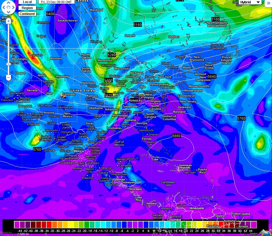
00Z GFS next Friday:
00Z Euro next Friday:

You can make out the front in the maps above with the greens and yellows across Mississippi, especially on the GFS. The brighter the colors, the more lift there is in the atmosphere equaling more rain. This translates to the surface in the form of a surface low pressure which is how we typically, not always, get substantial rains. The Euro isn't as gun-ho about the rain next Friday, it still has it but not a deluge like the GFS is currently showing. This low will have some cold air to develop snow on the northern side of it but that's not going to be an issue for us. If recent history has told us anything, this low will develop a bit more to our northwest than currently forecast but not by much. I am forecasting rain next Friday/Saturday with the timing needing to be worked out next week. Regardless, the front should usher in seasonable temperatures for Christmas morning which would be a pleasant gift! I will tease you with this bit of information: The Canadian model, another model I analyze, has us getting quite cold just after Christmas and is something I'll keep an eye on the next few days.
Enjoy your weekend! Here's your First Alert 7-Day Planner!
Thanks David. Saw that towards the 27th 28th. Might be interesting. I'll be watching as well!
ReplyDelete